It’s closing in on noon, and the day couldn’t be more perfect. The morning started out in a cool, mist-covered shroud, but now the sun is shining bright, trickling down as the pine-needled carpeted trail gently meanders uphill, past peeling madronas draped with Spanish moss. The thin air up at 8,000 feet makes for slow going, but the birds are singing and colorful patches of wildflowers are a welcome distraction. In front of you is a fern-like plant that appears small at first but grows larger as you get closer, until it dwarfs the rest of the forest understory. It’s a cool green, with massive fleshy leaves that look like they belong in a science fiction film in this seemingly familiar forest landscape.

“Agave,” says the guide, except this is not the agave of tequila country, waiting to be harvested for rowdy Americans in Tijuana. This is wild agave, plants that can live 20 to 30 years before yielding their last surprise, a powerful spike of flowers that shoots straight up in the air. At 10,000 feet above sea level, in one of the least-visited parts of Mexico, you’re a long way from Kansas. And a good thing too, since it’s the middle of winter.

This is the Sierra Norte of northern Oaxaca, a remote mountain range in central Mexico home to the Zapotec people, who first came to the area in 1000 B.C. Today, their ancestors still live in a half dozen mountain villages ranging in size from 700 to a mere 70 that are interconnected by an ancient trail system. To survive in a fast-modernizing world, these villages have chosen to embrace the outside world as a way to protect their way of life from the twin perils of depopulation and deforestation.

For now, this means inviting outsiders to explore the unique ecosystem that thrives at elevation (locals refer to the Zapotec as the “cloud people”) and experience day-to-day life in their communities. The Sierra Norte create a natural rain shadow for the winds that bring in rain and clouds from the Gulf of Mexico, allowing for overlapping microclimates that range from tropical forests to subalpine meadows and hardwood forests of “pinabetes,” 300 year-old pines that grow to nearly 100 feet.

But perhaps what’s most special about this out-of-the-way landscape are the natural juxtapositions created by its geography. The trail system is managed by the Pueblos Mancomunados, a local cooperative that provides employment and revenue opportunities for participating villages. Routes are vast and varied, and visitors can create almost any kind of hike, from a 5-mile, village-to-village stroll to a 50-mile trip through the entire system. Most choose to hire a local guide for each leg of their journey, both to contribute directly to the cooperative, but also because the crisscrossing trails of the Sierra Norte are notoriously easy to get lost in. (If you’d rather hike without a guide you’ll be required to sign a waiver.)
Permits can be obtained through the Expediciones Sierra Norte office in Oaxaca prior to the start of your trip. If you’ll need English-language assistance, it is recommended that you contact their U.S.-based partner, Crooked Trails—an educational nonprofit that works to sustain local communities and the environment—who can arrange for an English-speaking guide to accompany you on your trip.

One of the most popular hikes in the Sierra Norte is a 4-day circumnavigation of the region, stopping over each night at a new village. Starting from Cuajimoloyas, the trail travels 6-miles northeast to Llano Grande. It’s a short hike, so plan to head out in the afternoon on a 3-mile round-trip hike to watch the sunset from La Sepultura.
On your second, and longest, day of hiking, head northwest 13 miles following the Rio Yavesia until you reach the remote village of San Miguel Amatlan, situated on the slopes of the Sierra Norte midway between deep river valleys and 10,000-foot peaks. On the third day, you’ll travel southwest for 10 miles, dropping first into a deep river valley where the Rio El Arco and Rio Cara del Leon converge. Follow the Rio Cara del Leon upstream until you reach the village of Latuvi.

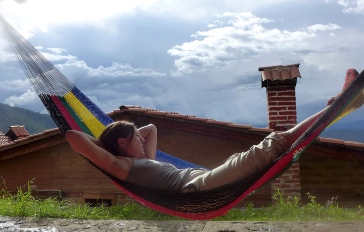
Get there early enough and spend the afternoon enjoying the view from one of their conveniently-situated hammocks. On the fourth day, travel southwest 5 miles to La Neveria before turning southeast and hiking the final 7 miles back to the start in Cuajimoloyas. Most visitors choose to stay in one of the cabins provided by the Pueblos Mancomunados, a system similar to village-to-village trekking through Europe, where travelers carry just their clothes and day-to-day items between inns. Each cabin contains comfortable sleeping accommodations and, to help visitors stay warm during the blistering cold nights, a fireplace. Traditional meals made from local ingredients are provided by the villagers. Hikers interested in a more traditional backpacking experience can choose instead to camp overnight at one of the two established sites in the interior of the Sierra Norte.
Experienced backpackers interested in a longer trip should stay tuned: Crooked Trails is currently teaming up with Expediciones Sierra Norte to create a two-week trek from the heights of the Sierra Madre de Oaxaca out to the ocean, winding through cloud forests into the humid jungle before tracing the remote and rugged coast.
To learn more about this long-distance trail project or to plan a multi-day trip through the Sierra Norte, contact Crooked Trails at: Info@crookedtrails.org
Written by Laura Lancaster for RootsRated and legally licensed through the Matcha publisher network. Featured image provided by Robin Anderson