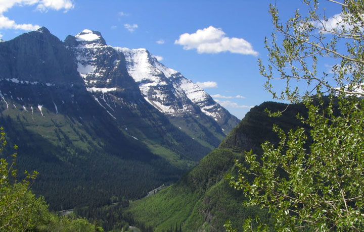
Glacier National Park, in northwestern Montana along the Canadian border, covers one million acres across several ecosystems (ranging from prairie to tundra) and the Continental Divide. Also known as the “Crown of the Continent”, this pristine environment is home to more than 1,000 different species of plants and hundreds of species of animals. Almost all of the original native species can still be found in the park, including grizzly bears, moose, and mountain goats, as well as endangered species like wolverines and Canadian lynxes. There are 700 miles of trails to explore within Glacier National Park.
The history of the park begins long before its national park designation on May 11, 1910. The mountains began forming 170 million years ago and these sedimentary rocks, known as the Lewis Overthrust, contain some of the best-preserved fossils of very early life in the entire world. Fast forward to 10,000 years ago, which is when archaeologists have determined was about the time the first Native Americans arrived in the area. More recently in the 1800s, the Blackfeet Indians lived in the eastern part of what is now the park, while the Flathead Indians lived in the western area (today they have reservations just outside the park boundaries). As explorers, such as Lewis and Clark, pushed west, interest in this area grew, and it became known for both its beauty and hunting opportunities. In 1895, Chief White Calf of the Blackfeet sold the majority of the land to the U.S. government.
Glacier National Park has also been an important site for the study of the effect of climate change since the 1980s. It was estimated that of the 150 glaciers that existed in the park in the mid-19th century, just 25 were left in 2010, and they may all disappear by 2030 if current patterns continue.
CLASSIC ADVENTURES
Most people come to Glacier National Park for the hiking and camping and visitors can bike on most paved roads throughout the park. There are 130 named lakes and more than 600 total, so there are also some boating and fishing opportunities. The lakes are much quieter than the trails, and the park service rents out canoes and kayaks. A good option is taking the Swiftcurrent Lake in the Many Glacier area to Lake Josephine, which is often empty except for the one sightseeing boat that runs back and forth.
The park is so large that most people visit a section at a time, and could easily spend a whole vacation exploring each one! There is a good variety of nature walks, day hikes, guided hikes with rangers, and overnight treks, with both backcountry and designated campgrounds.

Going-to-the-Sun Road is a 50-mile drive through the center of the park. It’s arguably the most scenic road in the Continental U.S. and hits most of the popular spots. Logan Pass is a great place to stop and take the 1.5-mile Hidden Lake hike. This is a very popular and easily accessible hike, but most people are so busy looking at the scenery they don’t even notice the crowd! For a longer, more peaceful trek, try the 7.6-mile Highline Trail. It’s not for the faint of heart, as it involves walking along a sheer rock wall that is so exposed the Park Service has strung a hand cable along the wall, but the trail is practically parallel to the Continental Divide and has amazing views.
The Many Glacier area is the heart of the park and one of the most popular hikes here is to Grinnell Glacier. While Glacier National Park get crowded, it’s still not as crowded as other parks, so even the most “crowded” spots shouldn’t be that bad. The 11-mile roundtrip Grinnell Glacier trail starts at the Many Glacier Hotel and heads first to Lake Josephine, then through beautiful meadows to a steady 1,600-foot climb to the glacier viewpoint. Like most other places in the park, the scenery is breathtaking, but it’s also the chance to see a glacier before they all melt.

Looking for a real challenge with a great payoff? Take the Iceberg Lake trail. This strenuous 9.7-mile trail starts out pretty steep and then connects to the Ptarmigan Trail for a bit. This part of the trail has wonderful views of nearby peaks (Mount Grinnell, Swiftcurrent Mountain, and the largest of the three, Mount Wilbur), but is also prime grizzly bear country, so make plenty of noise and be very aware. The lake itself sits at just over 6,000 feet in elevation and is in the shadows of the surrounding mountains, so the ice that accumulates in the winter never really melts, hence the name Iceberg Lake.
SECRETS OF THE PARK
The Apikuni Falls Trail is an often-overlooked trail in the Many Glacier area. It’s just under two miles roundtrip, but the two-tiered cascading waterfall is worth the effort. It’s not possible to see the waterfall from the trailhead, but head towards the notch in the two mountains straight ahead. According to HikingGlacier.com , the falls are named after James Willard Schultz, who was given the nickname “Apikuni” from the Blackfoot Indians.

Kintla Lake has become a bit more popular in the recent years, but the trip out to the Northwest Corner area of the park is still not one that many are willing to undertake, especially when there is so much to see in the main areas (not to mention the bumpy and rough road). There is a campground at the lake and non-motorized canoes are allowed, so it’s worth at least an overnight stay. Take the 3-mile hike from Kintla Lake to Upper Kintla Lake and the views only get better.
IMMERSE YOURSELF
The best way to experience Glacier National Park is to spend a couple nights in the backcountry. Taking a guided hike with a park ranger is a great way to gain some backcountry experience and see the best of what the park has to offer, without having to think (too much) about things like grizzlies. If backcountry camping isn’t your thing, there are many wonderful day hike options within the different areas of the park. Above all, make time to visit a glacier (it is Glacier National Park, after all).
HOW TO GET THE MOST OUT OF YOUR VISIT
- Going-to-the-Sun road is weather dependent. Some years, the snow clears out by May, some years, not until July. The park starts to plow the road in April, but it could still snow after that, so check the park’s website before you go.
- The park is above 6,000 feet in elevation, so drink plenty of water and expect to be a little more out of breath than usual if you are coming from sea level.
- The best time to visit the park is summer and fall, but June, July, and August are the busiest tourist months.
- If you visit in the summer, consider taking the park’s free shuttle – it stops at all the trailheads and pullouts.
- Plan ahead to get a permit for a popular backcountry route. The permit reservations open in mid-March, but are only given out for half of the available slots. The rest are first-come, first-served, 24 hours in advance.
- Saint Mary Lake near the east entrance is the best spot to snap a photo – the lighting and the scenery make it one of the most gorgeous places in the park.
Written by Abbie Mood for RootsRated.